
How Drone Services Revolutionizing Arizona Construction
In Arizona’s bustling construction industry, staying ahead of deadlines and maintaining high-quality standards is essential. From Phoenix to Tucson, Southwest Drone Tech offers a powerful suite of drone services that are transforming construction project documentation, progress tracking, and planning. Whether you’re overseeing a commercial building in downtown Phoenix or a residential development in the heart of Tucson, drone technology provides unmatched insights and efficiency for construction projects across Arizona.
Drone services provide aerial perspectives and precise data that support everything from daily reporting to long-term planning. With the rapid adoption of this technology in Arizona, the ability to manage and showcase construction projects has reached new heights—literally. Southwest Drone Tech is at the forefront of this innovation in both Phoenix and Tucson, helping construction professionals make better decisions faster.
Key Benefits of Drone Services for Construction in Arizona
1. Enhanced Site Documentation
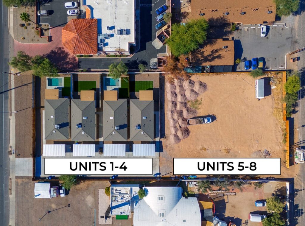
Construction sites in Arizona, whether located in the urban sprawl of Phoenix or the sprawling desert of Tucson, require accurate and consistent documentation. Drones capture high-resolution images and video from every angle, providing a comprehensive visual history of a project. Southwest Drone Tech ensures that your Arizona construction projects—whether in Phoenix, Tucson, or beyond—have the visual and data-based support needed for effective project management.
By using drones, project managers and stakeholders can access real-time, detailed data, reducing the need for constant on-site visits. This makes project monitoring in Phoenix and Tucson construction sites faster, safer, and more efficient.
2. Accurate Mapping and Surveying
Drones are game-changers for construction projects in Arizona. Whether working on a residential site in Tucson or a large commercial complex in Phoenix, drone mapping allows for efficient land surveying and project planning. Southwest Drone Tech uses state-of-the-art drone technology to capture detailed 3D models and topographic maps that help construction teams assess land features, elevations, and potential obstacles.
Drone mapping technology offers more precision than traditional surveying methods, ensuring that Arizona construction projects stay on track, especially in areas like Phoenix and Tucson, where land topography can vary significantly.
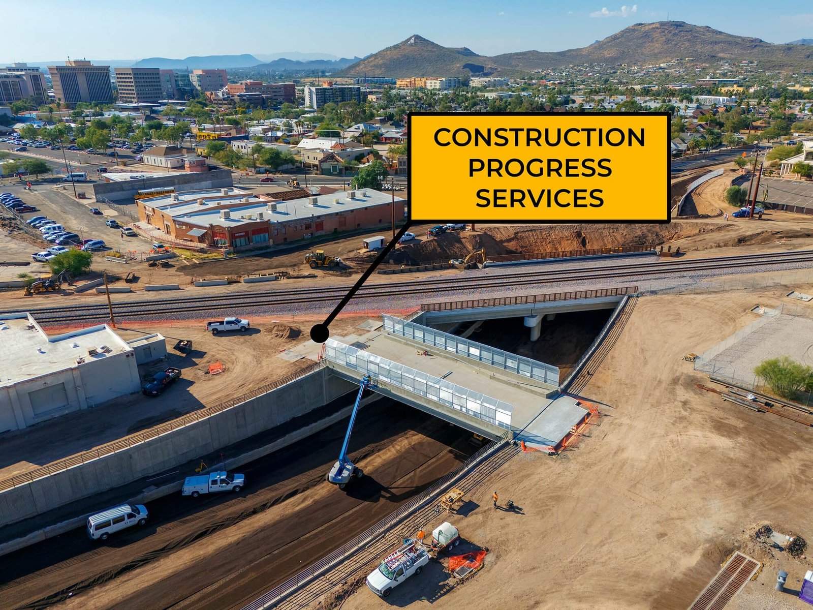
3. Timelapse Videos for Progress Tracking
For large-scale projects in Phoenix or Tucson, tracking progress over time is crucial. Drone timelapse videos provide a unique way to visualize a project’s growth, from groundbreaking to completion. Southwest Drone Tech specializes in capturing stunning time-lapse sequences that showcase the evolution of construction sites across Arizona.
Timelapse videos are perfect for monitoring progress in real time, helping project managers stay informed and investors see the development unfold. Whether it’s a highway project in Tucson or a skyscraper in Phoenix, timelapse videos offer an effective visual tool for tracking and marketing construction projects.
Construction Site Drone Services
Drone services in Arizona, whether for projects in Phoenix or Tucson, provide a range of solutions designed to meet the needs of construction teams, developers, and contractors:
Aerial Photography
- High-resolution images of construction sites
- Progress documentation for reporting
- Site inspection images, including hard-to-reach areas
Drone Video
- Real-time video updates on construction progress
- Promotional videos showcasing the project’s scale and design
- Site overview footage for marketing materials
Mapping and 3D Modeling
- Topographic maps for accurate site analysis
- 3D models of construction sites for planning and development
Timelapse Videos
- Visual progress tracking over time
- Construction time-lapse sequences for project reviews and marketing
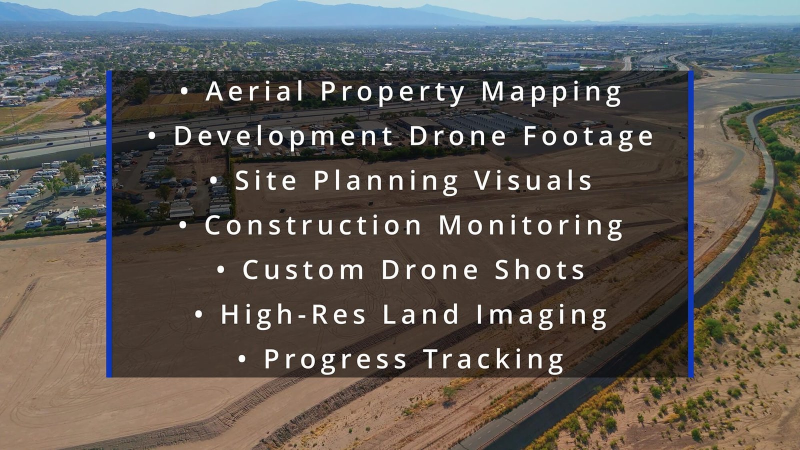
Additional Services
- Aerial Property Mapping: Detailed aerial views for property assessments
- Development Drone Footage: High-quality video for site monitoring
- Site Planning Visuals: Custom visuals for project planning
- Construction Monitoring: Regular updates to track progress
- Custom Drone Shots: Footage tailored to your project’s needs
- High-Resolution Land Imaging: Clear images for surveys and planning
- Progress Tracking: Visual documentation of development over time
Disclaimer: Southwest Drone Tech provides drone mapping and imaging services to supplement traditional surveying methods. We are not licensed surveyors.
Who Can Benefit from Drone Services in Arizona Construction?
Drone services are essential for anyone involved in construction in Arizona, especially for projects in Phoenix and Tucson. The following groups can benefit from drone services:
- Construction Companies: Use drones for site surveys, monitoring progress, and creating marketing content.
- Real Estate Developers: Capture aerial photos and videos of new developments for marketing and promotional purposes.
- Contractors: Easily track project progress and ensure everything is on schedule with timelapse footage.
- Investors and Stakeholders: Stay informed on project status through high-quality aerial images and videos.
- Surveyors: Use drone mapping and LiDAR technology for accurate land measurements and topographic data.
Conclusion
Drone technology is changing the way construction projects are executed and managed in Arizona. Whether you’re working in Phoenix’s urban environment or the desert landscapes of Tucson, drones offer unparalleled insights for progress tracking, documentation, and site analysis. Southwest Drone Tech provides top-tier drone services that streamline Arizona construction projects, improve planning, and save valuable time.
Ready to elevate your construction project in Phoenix, Tucson, or anywhere in Arizona? Reach out to Southwest Drone Tech today and take your project to new heights.
Southwest Drone Tech LLC Disclaimer
While Southwest Drone Tech LLC excels in aerial data collection, it is important to note that we do not provide interpretations of survey-grade information. For projects where precise measurements are essential, you must consult a licensed land surveyor or survey engineer. We can collaborate with your surveyor to supply valuable data, but our services do not replace the need for a licensed land surveyor in any jurisdiction.
We do offer visual markers or outlines of property areas in our imagery as part of our packages; however, these are for general visual reference only and are not legally binding or survey-grade. This standard applies universally to all drone data collection services unless they employ a licensed surveyor. We do not provide formal boundary delineations for home lots (whether developed or undeveloped) intended for sale due to these limitations.