
The Power of Drone Mapping: Benefits for Arizona's Key Industries
What is Drone Mapping?
Drone mapping utilizes unmanned aerial vehicles (UAVs) equipped with high-resolution cameras and advanced sensors to capture georeferenced images and data from an aerial perspective. These images are processed to create detailed outputs such as orthomosaics, high-resolution topographic maps, 3D models, and other visual and analytical representations of a site.
This cutting-edge technology allows for the generation of accurate elevation models, precise measurements, and comprehensive visualizations, making it an essential tool in industries like construction, agriculture, real estate, and more. By leveraging drone mapping, professionals can efficiently create orthomosaics, analyze elevation changes, and generate 3D models for enhanced planning and decision-making.
Drone mapping provides significant advantages over traditional methods, offering faster data collection, improved accuracy, and reduced costs. However, it is important to note that while Southwest Drone Tech delivers high-quality drone mapping services, we are not licensed surveyors. Our services are intended to complement traditional surveying methods and provide valuable visual data for informational purposes. For legally binding surveys or official land measurements, we recommend consulting a licensed surveyor.
How Drone Mapping Benefits Various Industries
1. Construction and Engineering
Drone mapping is an essential tool for construction projects in Arizona, whether in Phoenix, Tucson, or beyond. It helps construction professionals stay on top of site conditions, track progress, and plan for the next phases of a build. Aerial maps and 3D models provide real-time insights that improve project accuracy and streamline decision-making. Drone mapping helps:
- Survey land: Get precise topographic data without costly, time-consuming traditional surveying methods.
- Monitor progress: Track construction site progress with up-to-date aerial photos and 3D models.
- Inspect infrastructure: Perform detailed inspections of infrastructure like bridges, roads, and buildings.
VIEW DRONE CONSTRUCTION SERVICES
2. Agriculture and Farming
Farmers and land managers in Arizona can use drone mapping to optimize their land management practices. Drones equipped with multispectral cameras can monitor crop health, assess soil conditions, and identify issues such as pest infestations or nutrient deficiencies. This results in:
- Precision farming: Collecting data to make informed decisions about irrigation, fertilization, and pesticide application.
- Crop health analysis: Identifying areas of stress early to address potential problems before they affect yield.
- Field mapping: Capturing detailed field maps to support planning and resource management.
VIEW DRONE AGRICULTURE SERVICES
3. Real Estate
For real estate developers, agents, and investors in Phoenix and Tucson, drone mapping is an indispensable tool. It offers stunning aerial views of properties and helps potential buyers visualize a property’s layout and surrounding landscape. With drone mapping, you can:
- Create 3D models and topographic maps: Provide potential buyers with detailed property information.
- Showcase large estates: Highlight expansive land areas and outdoor features.
- Visualize new developments: Present 3D renderings of upcoming residential or commercial projects.
VIEW DRONE REAL ESTATE SERVICES
4. Land Surveying and Environmental Consulting
Drone mapping is a game-changer for land surveyors and environmental consultants who need to capture detailed site data quickly and accurately. Whether it’s conducting environmental impact assessments or performing routine site surveys, drone mapping can help:
- Survey large areas: Accurately map large and remote land areas without the need for extensive fieldwork.
- Monitor environmental changes: Track changes in vegetation, erosion, and water sources over time.
- Assess hazards and risks: Capture high-resolution data to identify potential hazards such as unstable slopes or flood zones.
5. Mining and Resource Management
In the mining industry, drone mapping is used to map large mining operations, monitor excavation progress, and improve safety. By providing detailed aerial maps, drone technology can help:
- Measure stockpiles: Capture data for accurate volume measurements of materials on-site.
- Assess mine conditions: Monitor dangerous or hard-to-reach areas of a mine with minimal risk.
- Track excavation progress: Visualize the movement of materials over time with time-lapse videos and 3D models.
Disclaimer: Southwest Drone Tech are not licensed surveyors. However, we can collaborate with your licensed surveyor to capture high-quality aerial data. Please note that we do not interpret the data, and for legally binding surveys or official land measurements, a licensed surveyor should be consulted.
Drone Mapping Deliverables for Professionals
Drone mapping produces several valuable deliverables that are essential for industries like construction, agriculture, real estate, and more. Here are some of the key outputs:
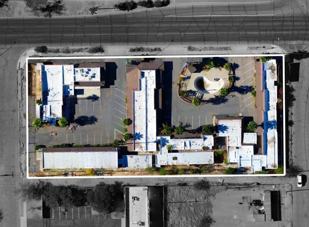
- Orthomosaic Maps: High-resolution, georeferenced images stitched together to create an accurate, large-scale map of a site.
- 3D Models: Detailed, interactive 3D representations of a site or structure, useful for planning and design.
- Topographic Maps: Maps that highlight elevation data, showing the terrain’s features for land use planning and development.
- Point Cloud Data: Highly detailed, 3D data sets that represent the physical features of a site, often used for measurements and analysis.
- Contour Maps: Represent the elevation changes across a site, essential for construction planning and flood risk assessment.
- Thermal and Multispectral Imaging: Data to assess environmental conditions, crop health, and building performance.
Use Cases of Drone Mapping
Here are some practical examples of how drone mapping is used across different sectors in Arizona:
- In construction: Mapping a new development site in Phoenix or Tucson to provide detailed site surveys and track progress.
- In agriculture: Creating multi-spectral maps to assess crop health and make data-driven decisions about resource allocation.
- In real estate: Capturing stunning aerial photos of a luxury home in Scottsdale or a commercial property in downtown Tucson.
- In land surveying: Surveying a remote desert landscape or mapping terrain for infrastructure projects with high accuracy and minimal environmental impact.
Who Can Benefit from Drone Mapping in Arizona?
Drone mapping is a versatile tool that benefits a wide range of professionals, including:
- Construction Professionals: Construction managers, architects, and engineers use drone mapping for site surveys, progress tracking, and 3D modeling.
- Agriculturalists: Farmers and crop specialists use drone mapping for monitoring crop health, soil analysis, and precision farming.
- Real Estate Agents and Developers: Realtors and developers use drone mapping for showcasing properties, creating 3D models, and offering detailed topographic maps.
- Surveyors and Environmental Consultants: Land surveyors and environmental consultants rely on drone mapping for accurate measurements, environmental monitoring, and site assessments.
- Mining Companies: Mining professionals use drone mapping for assessing site conditions, tracking excavation progress, and measuring stockpiles.
Why Choose Southwest Drone Tech for Your Drone Mapping Projects
Drone mapping is changing the way professionals across industries—whether in construction, agriculture, real estate, or land surveying—collect, analyze, and visualize data. In Arizona, from Phoenix to Tucson, this technology is offering a faster, more accurate, and safer way to conduct surveys, monitor progress, and make informed decisions. With its range of applications and powerful deliverables, drone mapping is a must-have tool for any modern industry.
Interested in leveraging drone mapping for your project? Contact Southwest Drone Tech to learn how we can help you collect precise data and enhance your operations.
Southwest Drone Tech LLC Disclaimer
While Southwest Drone Tech LLC excels in aerial data collection, it is important to note that we do not provide interpretations of survey-grade information. For projects where precise measurements are essential, you must consult a licensed land surveyor or survey engineer. We can collaborate with your surveyor to supply valuable data, but our services do not replace the need for a licensed land surveyor in any jurisdiction.
We do offer visual markers or outlines of property areas in our imagery as part of our packages; however, these are for general visual reference only and are not legally binding or survey-grade. This standard applies universally to all drone data collection services unless they employ a licensed surveyor. We do not provide formal boundary delineations for home lots (whether developed or undeveloped) intended for sale due to these limitations.