
Using Drone Photography to Document Property Conditions
When it comes to insurance claims, having a clear and accurate record of property conditions is essential for assessing damages and preventing disputes. Southwest Drone Tech specializes in using drone photography to capture high-resolution images that help insurance companies document property conditions quickly and efficiently. These aerial images provide an invaluable tool for pre-claim inspections, allowing for detailed evidence to back up claims and ensure fair assessments. VIEW DRONE INSPECTION SERVICES
What is Drone Photography?
Drone photography involves using unmanned aerial vehicles (UAVs) equipped with high-definition cameras to capture images from above. This aerial view provides a unique perspective that’s not possible with traditional ground-level photography. Drones can reach high or difficult-to-access areas, allowing for a comprehensive and detailed capture of properties, both inside and out.

How Drone Photography Benefits Property Condition Documentation for Insurance
- Comprehensive Property Condition Records
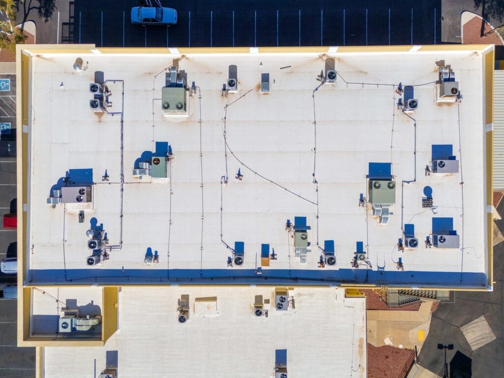
Before any insurance claim is filed, it’s crucial for insurance companies to have a documented record of a property’s condition. Drone photography captures comprehensive, high-quality images of the entire property, including hard-to-reach areas like rooftops, chimneys, and other elevated sections. This provides an accurate baseline that can be compared to post-damage images to determine the extent of any losses. - Detailed Aerial Views for Large Properties
For large properties, including commercial buildings or expansive homes, drones provide an efficient way to capture detailed aerial views. These views help insurers document the overall layout and condition of the property, identifying potential vulnerabilities or areas of concern that could affect the insurance claim. Whether you’re in Phoenix or Tucson, these images help create a more thorough assessment that can streamline the claims process. - Faster, Safer Inspections
Documenting property conditions traditionally requires insurance adjusters to conduct onsite inspections, which can be time-consuming and potentially dangerous, especially in hazardous or hard-to-reach areas. Drone photography eliminates these risks by capturing high-resolution images remotely, making inspections faster, safer, and more convenient. Insurance companies in Arizona benefit from this time-saving technology, improving operational efficiency while reducing the need for field personnel to access potentially unsafe locations. - Reduced Disputes with Accurate Documentation
Accurate documentation is critical in preventing disputes during the claims process. Drone photography provides unbiased, high-resolution images that offer indisputable evidence of property conditions before a claim is made. These images can be used to support or deny claims, ensuring that both insurance providers and policyholders have a fair, accurate representation of the property’s state. - Detailed Condition Reports for Specific Areas
Drones can capture images of specific areas of a property that might otherwise be overlooked during a traditional inspection. This includes roofs, gutters, and other difficult-to-reach parts of the building. For homeowners and business owners in Phoenix, Tucson, and beyond, drone photography offers a valuable tool to document conditions in detail, which can be especially useful in the event of roof damage, storm damage, or wear and tear from the elements.
Drone Photography Applications for Insurance Property Condition Documentation
- Homeowners: Ensure that your property’s condition is documented before filing a claim. Use drone photography to capture every angle of your property and avoid issues with inaccurate damage assessments.
- Commercial Property Owners: For large commercial spaces or multi-building complexes, drones provide an efficient way to document property conditions for insurance purposes, reducing the time needed for inspections.
- Insurance Adjusters: Use high-quality drone images to document the condition of a property before or after an event, streamlining the claims process and improving assessment accuracy.
Disclaimer
Please note that Southwest Drone Tech provides high-quality drone photography services, but we do not provide interpretation of the data. Our services are intended to capture and deliver visual data for informational purposes. For analysis or interpretation of property conditions, please consult an insurance adjuster or other licensed professional.
Improve Roof Inspections and Safety with Drones
Drone technology not only benefits your marketing efforts but also enhances safety and efficiency during inspections and repairs. Instead of manually inspecting hard-to-reach or damaged areas, drones offer a safer and faster solution for roofing assessments.
- Quick and Safe Inspections: Drones can inspect areas of the roof that are dangerous or difficult to access, reducing the need for ladders or scaffolding. This improves safety for workers and provides quicker, more detailed data for roofers.
- Accurate Measurements: Drones equipped with advanced software can provide accurate roof measurements and generate detailed reports. This ensures you can estimate the scope of work more efficiently and plan for resources effectively.
Conclusion
Drone photography is revolutionizing the way insurance companies document property conditions before claims. By providing detailed, high-resolution images, drones make inspections faster, safer, and more efficient while reducing the chances of disputes. Whether you’re in Phoenix, Tucson, or anywhere in Arizona, Southwest Drone Tech can help you document property conditions accurately and effectively.
For more information on how drone photography can assist with your property condition documentation, contact Southwest Drone Tech today! CONTACT US
Southwest Drone Tech LLC Disclaimer
While Southwest Drone Tech LLC excels in aerial data collection, it is important to note that we do not provide interpretations of survey-grade information. For projects where precise measurements are essential, you must consult a licensed land surveyor or survey engineer. We can collaborate with your surveyor to supply valuable data, but our services do not replace the need for a licensed land surveyor in any jurisdiction.
We do offer visual markers or outlines of property areas in our imagery as part of our packages; however, these are for general visual reference only and are not legally binding or survey-grade. This standard applies universally to all drone data collection services unless they employ a licensed surveyor. We do not provide formal boundary delineations for home lots (whether developed or undeveloped) intended for sale due to these limitations.