
Drone Services for Documenting Property Damage
When unexpected property changes occur—whether from tree trimming, roadwork, driveway damage, or storms, having clear documentation is key. Drone services, including aerial photography, video footage, and mapping, offer homeowners a detailed way to record these changes for insurance purposes, dispute resolution, or future repairs.
Disclaimer: We do not evaluate or assess the extent of the damage. Our role is solely to document the condition of the property for insurance or repair needs
Here are common scenarios where drone services can help:
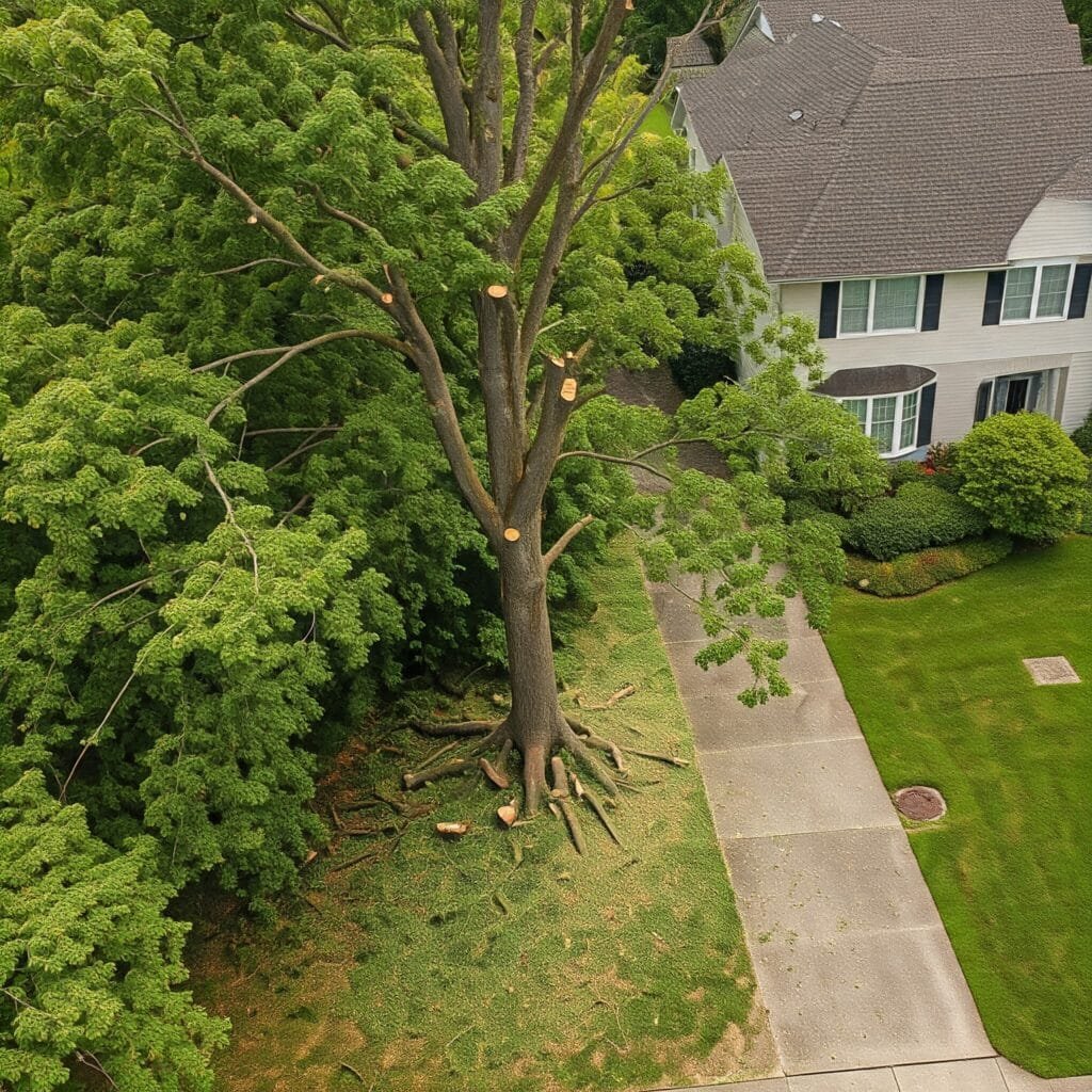
Tree Trimming and Landscaping Overreach
Tree trimming crews or landscapers may sometimes cut back more than anticipated, leading to disputes over the extent of the work or potential property damage. Drone photography provides an aerial perspective that captures detailed “after” shots, showing the exact modifications made to trees and landscaping. By comparing these drone images with pre-damage satellite imagery, homeowners can clearly demonstrate the overreach and use the visual documentation for corrective action or insurance purposes.
If you’re dealing with a similar issue, check out our PHOTOGRAPHY SERVICES for accurate documentation. Additionally, consider referring to industry reports on the impact of landscaping modifications on property values for further insight.
Roadwork and Construction Damage
Roadwork or nearby construction often results in unintended damage to private property, affecting driveways, sidewalks, or even landscaping. Drone services are ideal for capturing high-resolution aerial images and videos, which provide a detailed overview of the damage that may not be visible from ground level.
These images can be crucial when negotiating repairs or seeking compensation for property damage caused by construction activities. For fast, reliable aerial photography of roadwork-related property damage, explore our VIDEO SERVICES. You can also check out this report on the rise of drones in construction by DroneDeploy to understand the broader implications and advancements in the industry.
Driveway Damage
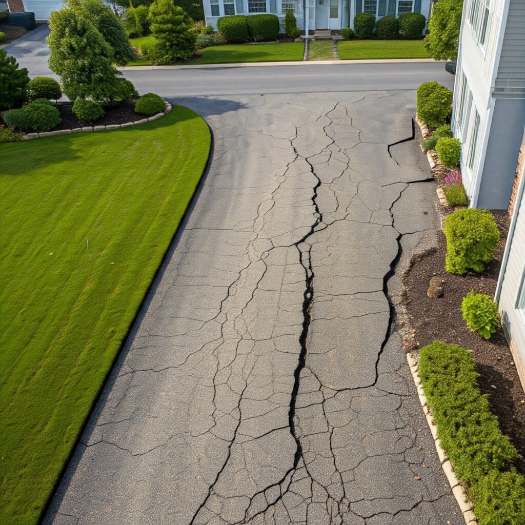
Heavy equipment from construction projects, delivery trucks, or utility repairs can sometimes crack or damage driveways, leaving homeowners with repair costs. Drone photography offers a unique top-down perspective that captures the full extent of driveway damage, providing clear visual evidence that ground-level images often fail to capture.
This aerial documentation can be vital when presenting your case for repairs or compensation. To learn more about how we can help document driveway damage, visit our AERIAL INSPECTIONS page.
HOA Modifications Without Notification
Homeowners sometimes face unexpected modifications from HOAs, such as the removal of trees, landscaping, or other property changes. Drone services can document these changes through aerial photography and video, providing clear evidence of the property before and after the alterations. Satellite imagery can provide a helpful baseline, allowing for accurate comparisons. To protect your property rights, explore our PHOTOGRAPHY SERVICES that capture changes from above.
Roof and Structure Damage
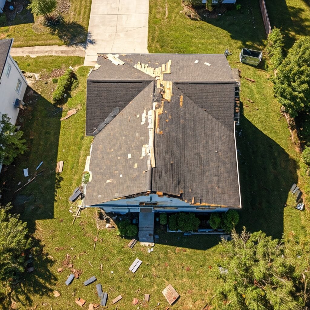
Drones are especially useful for inspecting hard-to-reach areas like roofs, where damage may go unnoticed from ground level. Whether it’s from tree branches, nearby work, or weather-related incidents, drones can quickly capture high-resolution photos or videos of the roof and other structures for insurance claims or repair estimates. For thorough inspections, consider our AERIAL INSPECTION SERVICES and ROOFING SERVICES that detail property conditions from multiple angles, ensuring nothing is overlooked.
Storm Damage Documentation
After a storm, it’s essential to document any property damage for insurance purposes. Drone services provide fast, comprehensive aerial documentation of storm damage, including roofs, fences, and other outdoor structures. Please note: We do not evaluate or assess the extent of the damage. Our role is solely to document the condition of the property for insurance or repair needs. For insights on how drone technology is aiding in insurance claims, check out this report on drones and storm damage assessments.
Before-and-After Comparisons Using Satellite Imagery
In many situations, satellite imagery can serve as a baseline for showing a property’s condition before any changes or damage occurred. When combined with fresh drone footage or photography, it’s easy to create before-and-after comparisons that highlight the extent of tree trimming, roadwork damage, or any other alterations. This combination is a powerful tool for resolving disputes or justifying repair costs. To see how we can assist with your aerial photography and video needs, visit our PHOTO/VIDEO EDITING SERVICES for high-quality enhancements of your images.
How Drone Services Can Help You
If you’re dealing with property changes or damage and need thorough documentation, here’s how to get started:
- Gather Pre-Damage Images: Collect satellite imagery or historical photos of the property to establish its original state.
- Hire a Drone Pilot: A professional drone pilot can capture current aerial images, video, or 3D maps of the property.
- Align and Compare: Use GPS-aligned drone footage to clearly show before-and-after differences.
- Present Your Evidence: With professional aerial documentation in hand, you can confidently present your case to an HOA, contractor, or insurance company to resolve the issue.
At Southwest Drone Tech, we specialize in capturing detailed aerial footage and images to document property damage. Whether you’re dealing with tree trimming, driveway damage, or storm-related issues, we provide fast, professional service in Tucson, Phoenix, and surrounding areas.
Why Choose Southwest Drone Tech for Your Roofing Projects
Drone services offer homeowners in Arizona a powerful and reliable way to document property changes and damage, whether from tree trimming, nearby roadwork, storm impacts, or unauthorized actions by Homeowners Associations (HOAs). Aerial photography, high-definition video, and precise mapping provide clear documentation that is invaluable for disputes, repairs, and insurance claims.
With the unique vantage point that drones offer, homeowners can gain a comprehensive view of their properties, highlighting issues that may be overlooked from the ground. This technology empowers proactive property management, ensuring homeowners have the necessary evidence to support their claims.
Whether you reside in Tucson, Phoenix, or nearby areas, our drone services cater to your specific needs. From stunning aerial images that enhance real estate listings to thorough inspections that identify maintenance issues, the applications of drone technology are vast. Additionally, storm damage assessments provide crucial documentation for expediting insurance claims.
At Southwest Drone Tech, we are dedicated to delivering fast, accurate, and professional drone services throughout Arizona. Our experienced team utilizes the latest technology to ensure you receive high-quality imagery tailored to your unique situation.
Don’t leave your property’s condition to chance—contact Southwest Drone Tech today to discover how our drone services can enhance your property management and documentation needs.
Southwest Drone Tech LLC Disclaimer
While Southwest Drone Tech LLC excels in aerial data collection, it is important to note that we do not provide interpretations of survey-grade information. For projects where precise measurements are essential, you must consult a licensed land surveyor or survey engineer. We can collaborate with your surveyor to supply valuable data, but our services do not replace the need for a licensed land surveyor in any jurisdiction.
We do offer visual markers or outlines of property areas in our imagery as part of our packages; however, these are for general visual reference only and are not legally binding or survey-grade. This standard applies universally to all drone data collection services unless they employ a licensed surveyor. We do not provide formal boundary delineations for home lots (whether developed or undeveloped) intended for sale due to these limitations.