
Insurance Inspections Using Drones for Faster Claims
When it comes to insurance claims, time is of the essence. Whether it’s for a home damaged by a storm or a commercial property that has suffered a loss, homeowners and insurers need accurate and timely assessments to ensure a smooth claims process. Drone inspections have quickly become a game-changer in this space, offering a faster, safer, and more accurate way to assess properties. At Southwest Drone Tech, we specialize in providing high-quality drone inspections in Tucson, Phoenix, and across Arizona, helping insurance providers speed up claims while ensuring accuracy.
Disclaimer: Please note that while Southwest Drone Tech provides high-quality drone inspection services, we are not licensed surveyors or insurance adjusters. We do not interpret the data collected; our services are intended to capture and deliver visual and spatial data for informational purposes. For official assessments or claims interpretations, we recommend consulting licensed professionals.
How Drone Inspections Speed Up the Insurance Claims Process
Quicker Assessment and Documentation
Drone inspections allow insurance adjusters to quickly access hard-to-reach areas of a property and gather high-resolution imagery and video for claims assessment. In the past, this may have required days of scheduling, manual inspections, and possible delays. Today, a drone can capture the necessary images and data in a matter of hours, providing a fast, reliable overview of the damage.
Improved Safety
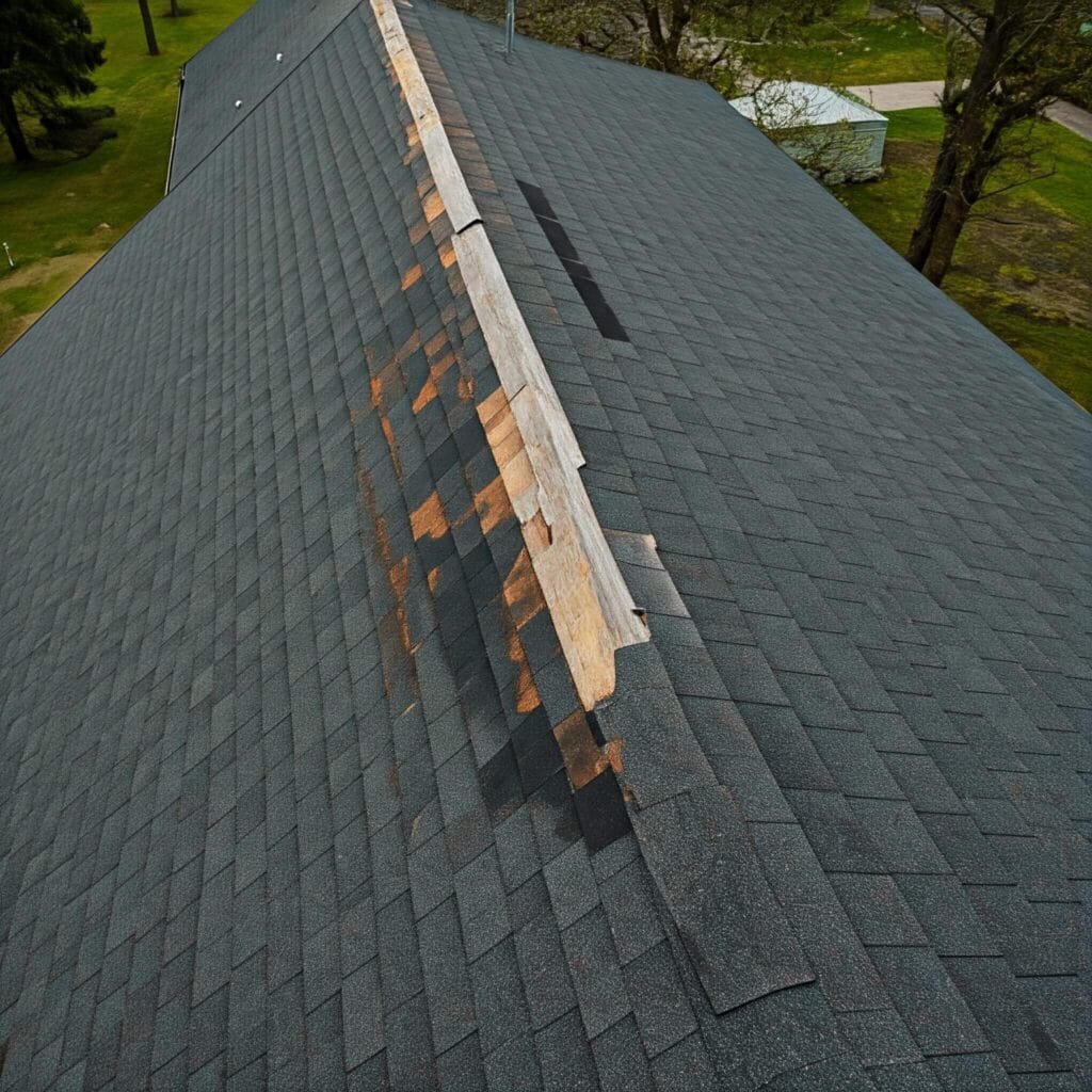
For properties with significant damage, such as roofs, high-rise buildings, or areas with hazardous conditions, drone inspections offer a safer alternative to traditional inspection methods. Insurance adjusters no longer need to climb ladders, scaffolding, or navigate dangerous environments. Drones capture detailed images from a safe distance, reducing the risk of injury and allowing claims to be processed more efficiently.
Accurate Data Collection
Drone technology has the ability to capture high-resolution imagery, thermal scans, and even 3D models of properties. These detailed visuals help insurance providers to assess the extent of damage more accurately, resulting in fewer mistakes and faster decisions. Drones can even map large areas, ensuring that no detail goes unnoticed. For example, drone inspections for insurance in Phoenix and Tucson can identify roofing issues, water damage, or structural damage with precision, which is invaluable when determining claim amounts.
Benefits of Drone Inspections for Homeowners and Insurance Providers
Faster Turnaround for Homeowners
For homeowners in Tucson or Phoenix who need to file claims, drone inspections ensure that assessments are completed quickly and accurately. Rather than waiting for days or weeks for an adjuster to schedule a traditional in-person inspection, homeowners can benefit from the speed of aerial inspections. The result? Faster claim approval and settlement.
Efficient Reporting for Insurance Providers
For insurance providers, the use of drones significantly streamlines the claims process. With drones capturing all the necessary data, the reports generated are comprehensive and highly detailed, saving time for adjusters and minimizing errors. Drone footage can be easily shared with clients or other professionals involved, ensuring transparency throughout the process. This helps to reduce the number of disputes and accelerate the claims handling process.
Use Cases for Drone Inspections in Insurance
- Homeowners’ Claims: Drones provide clear, detailed images of damage to homes, including roofs, yards, and exterior features, making the claims process faster and more accurate.
- Commercial Property Inspections: For large commercial properties in Arizona, drones can capture extensive footage of vast areas, reducing inspection time and offering a complete picture of property conditions.
- Natural Disaster Claims: After events like hailstorms, wildfires, or floods in Tucson or Phoenix, drones can survey affected areas quickly, providing insurers with the data needed to assess widespread damage.
- High-Risk Area Inspections: In cases where accessing a property would be dangerous, such as on high rooftops or in areas with debris, drones can safely provide the necessary images and footage.
Improve Roof Inspections and Safety with Drones
Drone technology not only benefits your marketing efforts but also enhances safety and efficiency during inspections and repairs. Instead of manually inspecting hard-to-reach or damaged areas, drones offer a safer and faster solution for roofing assessments.
- Quick and Safe Inspections: Drones can inspect areas of the roof that are dangerous or difficult to access, reducing the need for ladders or scaffolding. This improves safety for workers and provides quicker, more detailed data for roofers.
- Accurate Measurements: Drones equipped with advanced software can provide accurate roof measurements and generate detailed reports. This ensures you can estimate the scope of work more efficiently and plan for resources effectively.
Why Choose Southwest Drone Tech for Insurance Inspections?
Southwest Drone Tech offers professional drone inspection services tailored to the needs of insurance providers and homeowners in Tucson, Phoenix, and across Arizona. Our team uses cutting-edge drone technology to ensure that every inspection is completed with the highest level of accuracy and efficiency. Whether you need aerial footage, thermal imaging, or 3D mapping, we provide the data you need for faster, more reliable claims processing.
Are you ready to streamline your insurance inspections with fast, reliable drone technology?
For more information or to schedule a consultation, Contact Us Today!
Southwest Drone Tech LLC Disclaimer
While Southwest Drone Tech LLC excels in aerial data collection, it is important to note that we do not provide interpretations of survey-grade information. For projects where precise measurements are essential, you must consult a licensed land surveyor or survey engineer. We can collaborate with your surveyor to supply valuable data, but our services do not replace the need for a licensed land surveyor in any jurisdiction.
We do offer visual markers or outlines of property areas in our imagery as part of our packages; however, these are for general visual reference only and are not legally binding or survey-grade. This standard applies universally to all drone data collection services unless they employ a licensed surveyor. We do not provide formal boundary delineations for home lots (whether developed or undeveloped) intended for sale due to these limitations.