
The Benefits of Yearly Orthomosaic Mapping and Progress Imaging
For ranch owners, effective land management is key to maintaining a productive and profitable operation. Whether you’re managing pastures, monitoring water resources, or tracking development projects, staying on top of changes across your land is essential. This is where yearly orthomosaic mapping and progress imaging come into play, offering a high-tech way to monitor and manage your ranch year after year.
Aerial data collection via drones has transformed how ranch owners keep tabs on their properties, providing accurate, up-to-date information that can be shared with licensed land surveyors for detailed interpretation. Let’s dive into how this technology can improve ranch management and make a real difference in the way you track progress, assess land health, and plan for future projects.
1. Yearly Orthomosaic Mapping for Comprehensive Land Monitoring
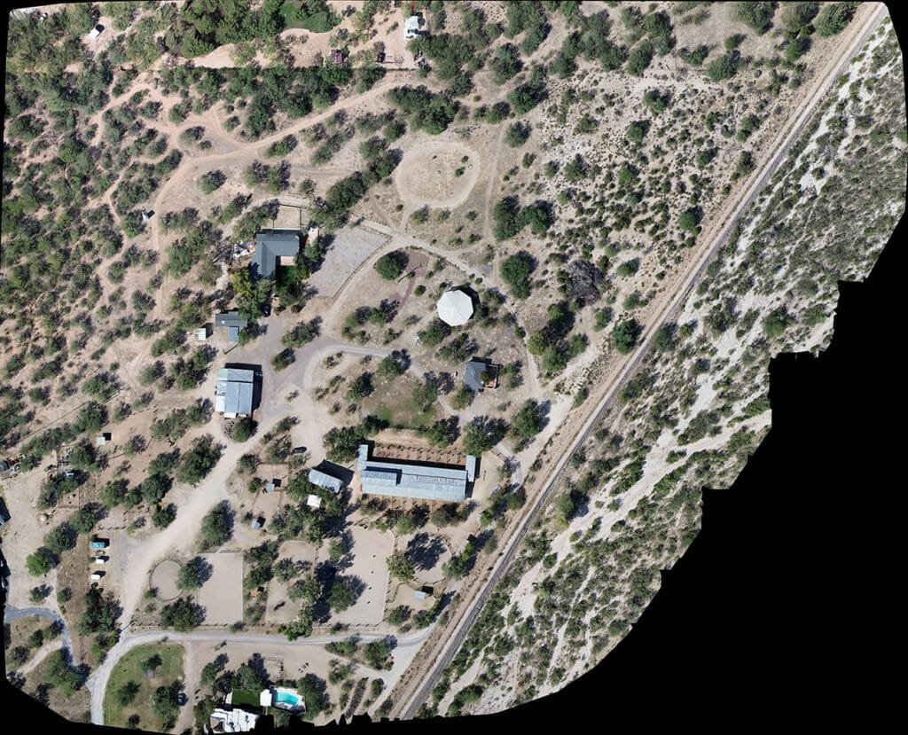
Orthomosaic maps are high-resolution, detailed images that provide a comprehensive view of your land. These maps are created by stitching together aerial images taken from drones, offering a georeferenced overview of your property.
By conducting yearly orthomosaic mapping, ranch owners can gain a bird’s-eye view of their entire property, which helps monitor and assess changes over time. Whether it’s new construction, changes in vegetation, or modifications to irrigation systems, yearly orthomosaics provide valuable baseline data that enables tracking of growth and development.
These maps are incredibly useful for understanding how different areas of your ranch are evolving, offering insights into:
- Pasture health: Spot areas where grass is sparse or overgrown.
- Water management: Monitor water flow and identify areas that may need attention.
- Land use: Track changes, whether for grazing, crop growth, or infrastructure development.
While these maps provide clear and actionable visual data, precise measurements and interpretations should be conducted by a licensed land surveyor. Orthomosaic maps serve as a crucial tool to guide discussions with professionals and support your land management goals.
Who Can Benefit from Drone Mapping?
Drone mapping is a versatile tool that provides valuable insights to a wide range of clients across various industries. Whether you’re looking to monitor land, plan projects, or manage resources more effectively, drone mapping can deliver the accurate, high-quality data you need. Here are some of the client niches that can benefit from these services:
- Ranch owners
- Farmers
- Homesteaders
- Homeowners
- Commercial real estate developers
- Property management companies
- Construction companies
- Land surveyors (for supplemental aerial data)
- Environmental consultants
- Utility companies
- Event venues
- Mining and resource management firms
- Landscape architects
- Insurance adjusters
- Government agencies (e.g., for land use or zoning assessments)
Drone mapping provides customized solutions for each of these industries, helping clients make smarter, data-driven decisions while saving time and resources.
2. Progress Imaging: Before-and-After Project Tracking
When it comes to land development or improvements on your ranch, tracking the progress of various projects is crucial. Whether you’re building new barns, creating fences, or expanding water systems, progress imaging helps visualize changes in a way that traditional photos can’t match.
By using drones to capture before-and-after images, you get an accurate visual representation of how a project has progressed over time. These images are powerful tools for:
- Project planning: Easily track milestones to ensure that work is being completed on schedule.
- Assessing quality: Identify any potential issues that might have been overlooked during construction or development.
- Documentation: Provide stakeholders, contractors, or investors with clear, documented evidence of progress.
Additionally, before-and-after imagery can be a valuable resource when reviewing the results of land reclamation projects, erosion control, or vegetation management efforts. You can visually compare the land’s condition before the project began and after it was completed, helping you determine if the work has met your goals.
3. Enhancing Decision-Making with Accurate, Up-to-Date Data
The more data you have about your ranch, the better equipped you are to make decisions that benefit your bottom line. Drone-captured orthomosaics and progress images give you detailed insights into every corner of your land, allowing you to monitor everything from soil health to irrigation needs.
By having access to accurate, high-resolution data, ranch owners can:
- Improve resource allocation: Identify areas that require more attention and focus resources where they’re needed most.
- Monitor seasonal changes: Keep track of vegetation growth, water distribution, and other factors that change throughout the year.
- Optimize operations: Plan new projects or improvements with a clear understanding of the land’s current state.
Drone data makes decision-making faster, more informed, and more precise—empowering ranch owners to make the most of their land while reducing guesswork.
4. Save Time and Money with Aerial Data Collection
Traditional land assessments and on-the-ground inspections are time-consuming and costly. Drones, however, can quickly cover large areas in a fraction of the time it would take to walk or drive across the property.
Yearly orthomosaic mapping and progress imaging via drones also save ranch owners the hassle of coordinating large teams or waiting for lengthy processes. With drones, you get the data you need quickly and efficiently, allowing you to make adjustments and decisions without the added costs of traditional methods.
However, if precise, survey-grade measurements are required for legal or regulatory purposes, you’ll need to work with a licensed surveyor. Drone data serves as an excellent foundation to supplement their expertise.
5. Improve Sustainability with Better Land Management
With the ability to monitor changes and trends over time, drones help ranch owners be more proactive in managing their land sustainably. Whether it’s tracking water usage, spotting overgrazed areas, or identifying erosion hotspots, drone data provides key insights that can improve the sustainability of your operations.
Aerial mapping allows you to assess soil health, manage vegetation growth, and reduce the environmental impact of your land management practices. By integrating drone data into your decision-making process, you can make better, more sustainable choices for the future of your ranch.
A New Era of Ranch Management with Drone Mapping
Yearly orthomosaic mapping and progress imaging offer ranch owners a powerful, modern way to monitor, manage, and improve their land. By utilizing drone technology, you gain accurate, up-to-date data that allows you to make smarter decisions, optimize operations, and track the progress of your projects.
At Southwest Drone Tech, we specialize in providing high-resolution aerial imagery and mapping services tailored to the needs of ranch owners in Arizona. Whether you need yearly updates, progress reports, or detailed visual data, we’re here to help elevate your ranch management. Contact us today to learn more about how our drone services can benefit your ranch!
Southwest Drone Tech LLC Disclaimer
While Southwest Drone Tech LLC excels in aerial data collection, it is important to note that we do not provide interpretations of survey-grade information. For projects where precise measurements are essential, you must consult a licensed land surveyor or survey engineer. We can collaborate with your surveyor to supply valuable data, but our services do not replace the need for a licensed land surveyor in any jurisdiction.
We do offer visual markers or outlines of property areas in our imagery as part of our packages; however, these are for general visual reference only and are not legally binding or survey-grade. This standard applies universally to all drone data collection services unless they employ a licensed surveyor. We do not provide formal boundary delineations for home lots (whether developed or undeveloped) intended for sale due to these limitations.