
Preserving History with Drone Mapping at Sasco
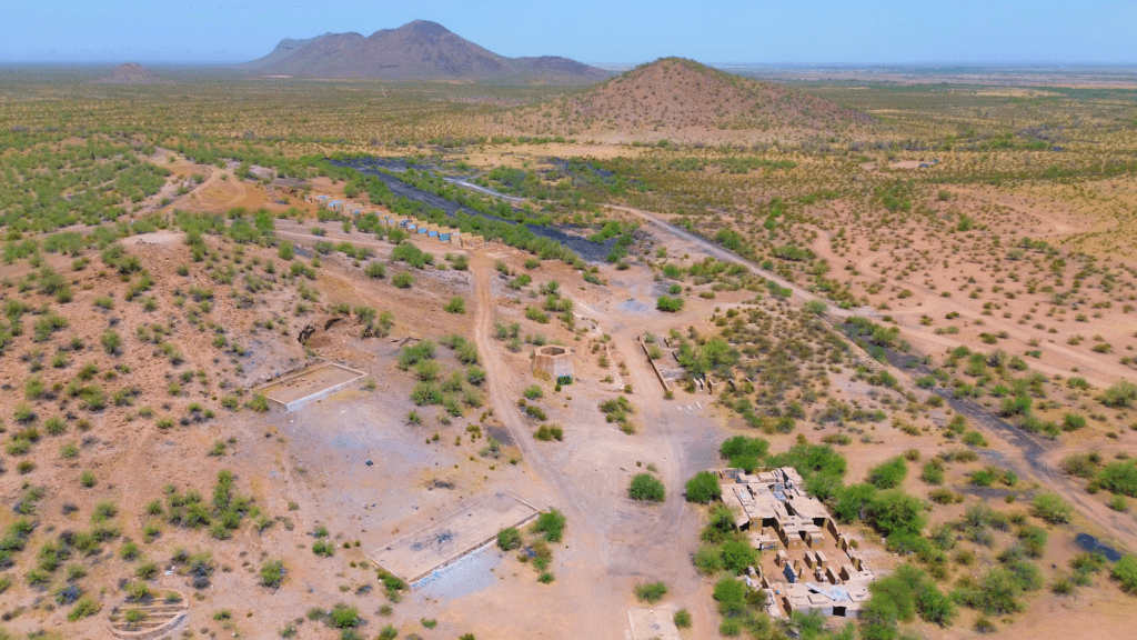
Sasco, Arizona, once a bustling company town centered around a smelter serving nearby mines, now stands as a testament to early 20th-century industry and community life. As the remnants of Sasco face the ravages of time, drone mapping technology offers a groundbreaking way to document, analyze, and preserve this historical site. Southwest Drone Tech is at the forefront of this effort, using advanced drone mapping to create detailed models and maps that capture Sasco’s legacy for future generations.
Please note that this information is not an official historical preservation record, and I am not affiliated with any government entity.
The Historical Significance of Sasco

Image Source: Public domain, via Wikimedia Commons
Founded in the early 1900s, Sasco (Southern Arizona Smelting Company) played a pivotal role in processing ore from surrounding mines. The town was equipped with a smelter, a hotel, post office, and housing for workers, making it a self-sufficient community. Today, the remnants of Sasco’s buildings, foundations, and industrial structures provide invaluable insights into the region’s mining history and early 20th-century life.
Utilizing Drone Mapping for Preservation
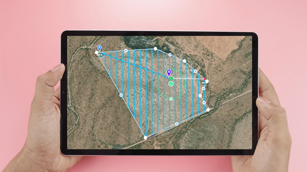
Drone mapping offers an innovative approach to preserving historical sites like Sasco. By using automated drone flights and advanced photogrammetry techniques, we can capture high-resolution images and create detailed 3D models of the site. This method allows us to document Sasco’s current state comprehensively, ensuring that even the smallest details are recorded for posterity.
Use Cases of Drone Mapping in Historical Preservation

- Detailed Site Documentation: High-resolution aerial imagery and 3D models provide an accurate representation of Sasco’s layout and structures. This data is invaluable for historians and archaeologists studying the site.
- Change Monitoring: By conducting regular drone surveys, we can monitor changes and deterioration over time, helping to inform conservation efforts.
- Public Engagement: Interactive 3D models and virtual tours created from drone data can be shared with the public, enhancing awareness and appreciation of Sasco’s historical significance.
- Educational Resources: Schools and universities can use the detailed maps and models for educational purposes, allowing students to explore the site virtually and learn about its history.
- Planning Restoration Efforts: Detailed drone data aids in planning any potential restoration or stabilization efforts by providing precise measurements and condition assessments.
Processing the Data
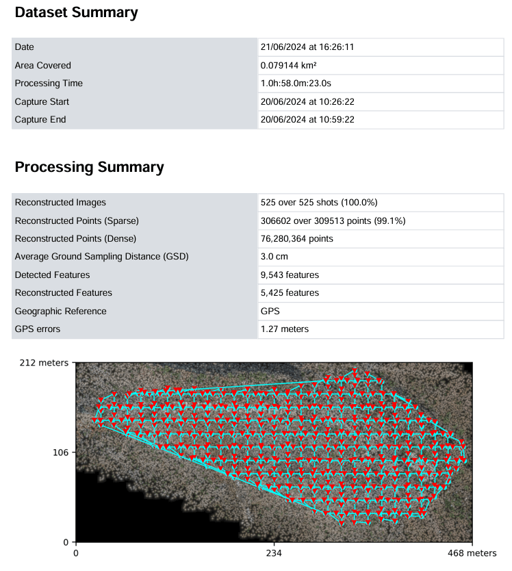
Once the drone flights are completed, the captured data is processed using advanced software to create accurate 3D models and orthomosaic maps. This process involves stitching together thousands of high-resolution images to produce detailed representations of the site. The resulting models can be analyzed, shared, and archived, ensuring that Sasco’s legacy is preserved digitally even as the physical site continues to weather.
Detailed site documentation of Sasco benefits significantly from the integration of advanced drone technologies, which include precise GPS, comprehensive metadata, orthophotos, and sophisticated 3D models.
GPS and Metadata: At the core of accurate site documentation is the use of high-precision GPS technology. Drones equipped with GPS capture imagery with exact geospatial coordinates, ensuring that every photograph and measurement is accurately mapped to its real-world location. The metadata embedded in the drone data includes critical information such as camera settings, flight altitude, and GPS coordinates, providing context and accuracy to the imagery and models. This metadata is essential for verifying the precision of the data and for future reference, as it details the conditions under which the data was collected.
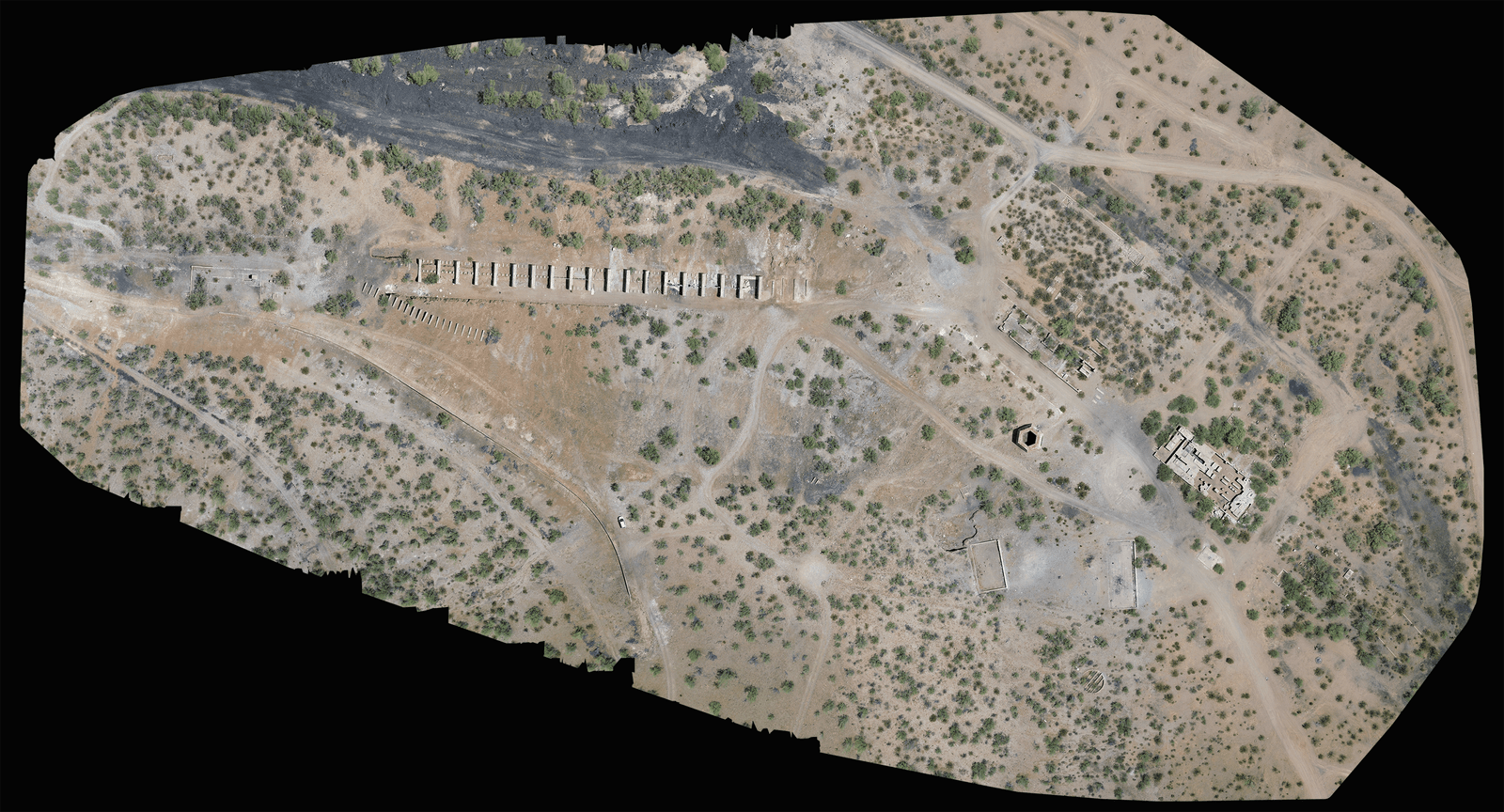
Orthophotos: Orthophotos, or orthorectified images, are another crucial component of detailed site documentation. These are high-resolution aerial photographs that have been corrected for distortions, ensuring that each image accurately represents the Earth’s surface. Orthophotos provide a clear, scale-accurate view of the site, making it easier to analyze and measure features. They are particularly valuable for creating detailed maps of Sasco, as they combine the clarity of photographs with the precision of cartographic accuracy.
3D Models: The creation of 3D models from drone data further enhances the documentation and analysis of the site. Using data from multiple overlapping images, photogrammetry software constructs detailed three-dimensional representations of the site’s structures and terrain. These models offer an immersive view of Sasco, allowing historians, archaeologists, and conservationists to examine the site from various angles and perspectives. The 3D models can reveal intricate details that might be missed in traditional photographs or maps, such as the subtle changes in elevation or the condition of specific structures. Additionally, interactive 3D models and virtual tours can be shared with the public and used in educational contexts, providing a dynamic way to engage with the site’s historical significance.
Together, GPS technology, detailed metadata, orthophotos, and 3D models create a comprehensive and accurate representation of Sasco. This combination supports effective documentation, change monitoring, and planning for conservation efforts, while also providing valuable educational and public engagement opportunities.
Data Results
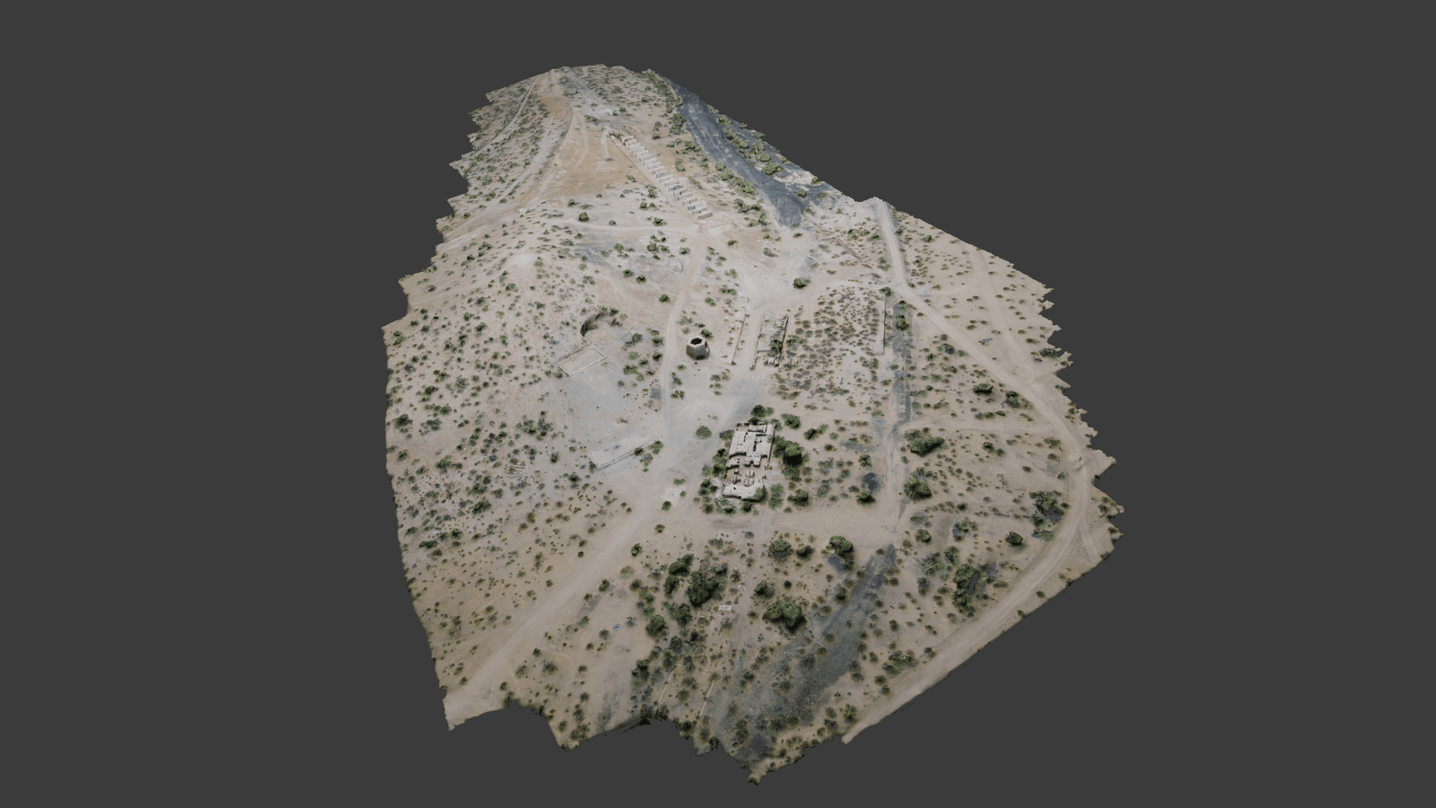


Explore the detailed layers of Sasco through this comprehensive slideshow. Starting with the orthophoto, you’ll see a high-resolution, distortion-corrected aerial view of the site, offering an accurate representation of the surface features. The 3D model provides a dynamic, interactive perspective, allowing you to examine the site’s layout and structures in three dimensions. The Digital Surface Model (DSM) highlights the elevations of buildings and vegetation, while the Digital Terrain Model (DTM) focuses on the ground surface for a clearer understanding of the topography.
Our flight planning and GPS accuracy data ensure that each image and model is precisely mapped, supporting accurate analysis and documentation. This combination of advanced drone technologies offers an in-depth look at Sasco, enhancing both historical research and conservation efforts.
Final Thoughts
Drone mapping technology is revolutionizing the way we document and preserve historical sites like Sasco, Arizona. By capturing detailed aerial imagery and creating comprehensive 3D models, we can ensure that the story of Sasco is preserved for future generations. As we continue to explore the potential of this technology, Southwest Drone Tech remains committed to using innovative solutions to protect and promote our shared heritage.